
|
How to create waypoints |
|
You can create a list of waypoints with Global Sites Editor found in EZSurv. Then you can bring the list of waypoints on the mobile device to use it with EZField.
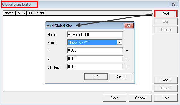
How to create waypoints 1. Start EZSurv, from the main menu, select Tools > Global Sites; |
|
2. You can manually Add your waypoints or Import them. ■ When you Add a waypoint using a Mapping Format, you need to enter the coordinates in the current coordinate system in EZSurv. You can change this projection with Tools > Mapping Systems > Selector... (for more details, refer to the article called How to select a pre-defined Mapping System) ■ Import is used to import a previously exported Global Sites List (GlobalSites.cdx and GlobalSites.dbf files) 3. Once your waypoint list is completed, Export it to a folder; 4. Using Windows Mobile Device Center (or ActiveSync), plug your mobile device to your personal computer and Copy/Paste the exported files (GlobalSites.cdx and GlobalSites.dbf) on your mobile device in the Sites folder found in Application Data\Effigis. 5. You can now use the global sites you’ve just imported as waypoints in your mobile application. Refer to the article called How to navigate for more details. |
|
Article: 000096 Related Products: EZField Last Update: 2016-07-14 18:44:15 |
|
Document information |
|
|